3 Methodology
The research strategy and field methods were designed to evaluate the prehistoric habitation on the local landscape level. Sampling through augering has proven very effective for this type of research (Bats 2007; De Bie & Van Gils 2009). It enables the investigation of large surfaces with a reasonable amount of fieldwork. Augering is aimed at identifying the locations of artefact concentrations. A restriction of this sampling technique is that it mostly yields undiagnostic artefacts and that a precise interpretation of the size of the identified concentration, its function, date or spatiotemporal homogeneity is not possible.
As the southern fringe of the dune complex of the Liereman Landscape proved too extended for complete coverage even with this methodology, several sample areas were selected at approximately regular intervals (fig. 2a, 2b: 1-4: white polygons). The survey and evaluation research was conducted in three phases for which different field methods were employed.
First, a reconnaissance augering survey with a 7 cm diameter Edelman auger in a 50x50 m rectangular grid was conducted to locate zones where the pre-Holocene topography seemed (nearly) intact. The presence of a well-developed podzol soil on top of this topography was considered the key indicator for both the absence of recent human disturbance and of (sub-)recent deflation. Field observations and cartographical information on land-use, hydrography and topography were added. Detailed topographical information was derived from Lidar data, on the basis of which a digital elevation model (DEM) with 1m grid cells was constructed (fig. 2a, 2b).
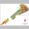
In a second phase, selected zones where the palaeolandscape was thought to be well-preserved were investigated for the presence of archaeological remains (fig. 2a, 2b: 1-3: red polygons; 4: white polygons). In a 5x6 m triangular grid, and for some peripheral areas in a 10x12 m grid, an Edelman auger with a 20 cm diameter was used to sample the deposits to an average depth of 85 cm, i.e. well below the B-horizon of the podzol. The sediment column of each core was divided in three equal parts in function of depth and sieved on a 3 mm mesh. Archaeological finds, sediment and soil characteristics were recorded.

|
Fig. 5a Archaeological survey in zone 4 on elevation map (yellow: high; blue: low; heights were measured at each auguring location). Red dots: corings with lithic artefacts, dot size correlates with the number of finds. Crosses: other corings. Black square:
figure 5b
.
|
Finally, test pits were dug in zones 2 and 4 to provide detailed information on the stratigraphical relation between the artefact scatters and the formation history of the ridge. More precise information was also expected on preservation conditions and scatter densities, and more diagnostic artefacts should improve the chrono-cultural identification. In zone 4, three pits and a coring transect from the top of the sand ridge towards the eastern depression were studied in detail (fig. 5b). The test pits were dug by trowelling, while the finds were recorded in three dimensions. Additionally, the sediment was sieved per square metre and per 10 cm on a 3 mm mesh.
A test pit in zone 4 confirmed a clear association of artefacts with a whitish horizon, which was interpreted as the result of a bleaching process typical for the Usselo horizon (see below). The horizontal extent of this horizon and the presence of associated artefact concentrations was prospected in a 0.5 ha area (fig. 5b: red line). The 20 cm Edelman corings were extended there to an average depth of 135 cm to trace the Usselo horizon, which was sieved separately when present. For transect drilling, a 3 cm gouge auger was used in order to maximise visibility as the bleached horizon was not always clearly visible.

|
Fig. 5b Zone 4, northeastern part, with pits A-C. Red line: systematic survey of Usselo horizon . Small crosses: corings. Thick crosses: transect of geomorphological corings (
fig. 8
). White polygons: Usselo horizon attested. Red circles: corings with lithic artefacts in Usselo horizon.
|
